Motivation
Today, numerous information systems and services are developed to search, browse and download marine data, such as
• Satellite and aircraft images
• Human observations from vessels, helicopters and in the field
• In situ measurements from buoys, instruments mounted on vessels and land-based stations
• Forecasts from weather, metocean, ecosystem and drift models.
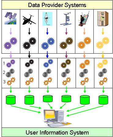
However, these systems are not fully interoperable, and do not allow users to view, access, process, and analyse data from different providers without further processing. Current systems are typically based on custom-built or proprietary software. Thus, users need tools of their own to read and extract (1), reformat (2) and reproject (3) relevant parts of the retrieved datasets, before being able to visualise and analyse them together. This is time consuming and improving interoperability between marine data systems is therefore needed for more efficient data usage.
|
This project was partially funded by the European Commission under Theme ICT-2009.6.4 ICT for environmental services and climate change adaptation of the Information & Communication Technologies FP7 Programme |
|
Paper on NETMAR semantic resources published
Thu, 04/11/2013 - 17:10 — netmarThe paper Putting meaning into NETMAR the open service network for marine environmental data describes the development of two semantic resources for discovery and validation of Web Processing Services and to support interoperability of coastal web atlases. The paper addresses both the formal representation as well as the tools and methods used to develop these semantic resources.
NETMAR @ EURIGI 2013
Thu, 03/14/2013 - 13:52 — netmarYassine Lassoued, CMRC, presented the NETMAR semantic framework and CSW Mediator at EUROGI 2013. See the slides here.
Ontology development presented at AGU 2012
Mon, 12/10/2012 - 15:18 — netmarAdam Leadbetter, BODC, presented the NERC Vocabulary Server V2.0 and the NETMAR Oceanography Thesaurus at
AGU 2012, 3-6 December, San Francisco, USA. See the poster here.
NETMAR @ EuroICAN 2012
Tue, 12/04/2012 - 08:41 — netmarDeclan Dunne, CMRC, and Adam Leadbetter, BODC, presented NETMAR at the EuroICAN workshop in Ostend, Belgium, on 26 November. Presentations:
NETMAR presented to Arctic ROOS community
Tue, 12/04/2012 - 08:40 — netmarStein Sandven, NERSC, presented NETMAR at the Arctic ROOS annual meeting in Sopot, Poland, on November 7.
See the slides here.